San Mateo County Southern Bayside Cities Shoreline Resilience Plan
Project Overview
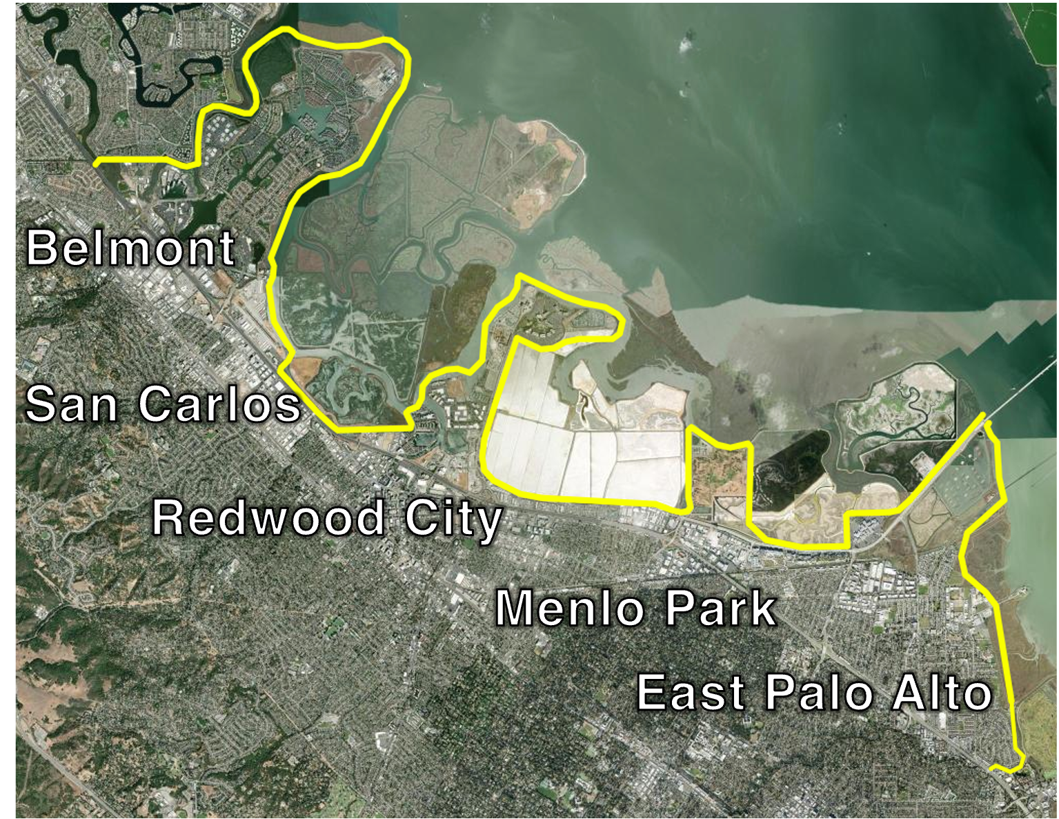
Beginning in early 2027, OneShoreline will lead the development of the San Mateo County Southern Bayside Cities Shoreline Resilience Plan, also known as the 5 Cities Plan. This 3-year planning effort aims to create a shared vision for the future of nearly 20 miles of San Francisco Bay shoreline along the Cities of Belmont, San Carlos, Redwood City, Menlo Park, and East Palo Alto. OneShoreline is partnering with these five cities and is planning to engage communities and stakeholders in the area to ensure that local knowledge and priorities are reflected in the final Plan.
California requires that all coastal and Bay-adjacent jurisdictions adopt sea level rise adaptation plans by 2034 (see Senate Bill 272, passed in 2023). The 5 Cities Plan will satisfy that requirement for all five cities. Guided by the San Francisco Bay Conservation and Development Commission's (BCDC) Regional Shoreline Adaptation Plan (RSAP) framework, the 5 Cities Plan will provide a coordinated roadmap for future shoreline investments and policies across all five cities well ahead of the 2034 deadline.
Beyond meeting a planning requirement, development of the 5 Cities Plan presents an opportunity to shape a resilient, connected, and thriving shoreline for generations to come. By working together, OneShoreline and the five cities can identify shared priorities, coordinate investments, strengthen natural and built infrastructure, expand public access, support habitat restoration, and prepare communities for future shoreline conditions.
This multi-jurisdictional planning approach recognizes that the Bay functions as a connected system, and that sea level rise and flooding do not stop at city boundaries. San Mateo County’s Southern Bayside shoreline includes businesses, highways, rail lines, utility systems, trails, parks, wetlands, and areas that support the economy and well-being of the broader region. Planning together allows the five cities and OneShoreline to identify shared priorities, reduce risk more effectively, and pursue funding for projects that provide benefits across jurisdictions.
Project Objectives
Through this planning effort, OneShoreline and the five cities will:
- Update our understanding of which neighborhoods, roads, utilities, natural areas, businesses, and community assets are most vulnerable to sea level rise, flooding, rising groundwater, and related hazards.
- Evaluate future flood projections through mid-century and end of century using the latest State of California sea level rise projections.
- Consider how multiple hazards can combine, including sea level rise, stormwater flooding, creek flooding, groundwater rise, and potential contamination risks in low-lying areas.
- Identify adaptation strategies for priority shoreline areas, including nature-based solutions, infrastructure improvements, land use and policy tools, and phased approaches that can adapt over time.
- Coordinate planning across city boundaries so that shoreline resilience decisions work together across the Southern Bayside shoreline.
- Incorporate community input throughout the process, with particular attention to communities that may face greater flood risk or have fewer resources to prepare, respond, and recover.
- Develop a clear implementation and funding strategy so the five cities and OneShoreline are better positioned to compete for federal, state, regional, and private funding.
- Prepare a final plan for approval by each of the five city councils and by BCDC.

Funding
The 5 Cities Plan is funded by the California Ocean Protection Council (OPC) under the Senate Bill 1 Sea Level Rise Adaptation Grant Program. The grant amount is $2,033,726, with an end date in June 2029. Local matching funds will be provided through in-kind contributions in the form of staff time from OneShoreline and the five partner cities.
Timeline
Procurement of a technical consultant team to develop the 5 Cities Plan will begin as early as mid-August but no later than the end of September, 2026. The final San Mateo County Southern Bayside Cities Shoreline Adaptation Plan is anticipated in early 2029. A full project schedule will be released by early 2027.
Opportunities for Feedback
There will be multiple opportunities for the community and other stakeholders to provide meaningful input during the planning process. Please check back for more information and subscribe for updates using the form above.
Project Contact
Clare Keating, Project Manager
Email: ckeating@oneshoreline.org
- Belmont Vulnerability Assessment (2025)
- San Carlos Climate Mitigation and Adaptation Plan (2021)
- San Carlos Pulgas Creek Study (2025)
- Redwood City Sea Level Rise Vulnerability and Adaptation Planning Study (2024)
- Cargill Final Environmental Assessment (2025)
- Menlo Park's Annex in the 2021 San Mateo County Multijurisdictional Local Hazard Mitigation Plan (LHMP)
- Menlo Park's 2030 Climate Action Plan (2024)
- Strategy to Advance Flood Protection, Ecosystems, and Recreation along San Francisco Bay (SAFER Bay) Project Description (2024)
- East Palo Alto 2030 Climate Action Plan and Adaptation Strategies (2023)
- East Palo Alto Vulnerability Assessment (2025 Public Draft)